This is the sixth in a series of posts about my East Coast US trip in March 2013 (see the first part, second part, third part, fourth part, and fifth part).
My third day in New York started off very sunny, and I had planned to take the Staten Island ferry (which is free!) on a round trip to get photos of the Statue of Liberty. Sadly, Liberty Island itself was still closed due to the damage caused by Hurricane Sandy in October 2012, so I wouldn't be able to see the famous Statue from any closer. My plans changed however when my lovely host Dee convinced me to take the Circle Line ferry tour of Manhattan Island - a 3 hour boat ride complete with commentary that encircled the entire island. I'm very glad that she convinced me to take this ferry tour; it's very cheap, terrifically informative, and a great way of seeing the scope of Manhattan.
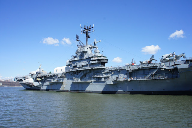
The Circle Line ferry departs from Pier 83, just near West 42nd Street and 12th Avenue. You have to pick up your ticket at the pier (booking online gives you a printable voucher that can be exchanged for a ticket up to a year in the future); I arrived about 30 minutes before the first departure of the day, but ended up getting a ticket for the later 3pm departure since the lines move very slowly. Now with 3 hours to kill, I searched around for other entertainment, thankfully finding some just next door at Pier 86 (West 46th Street and 12th Avenue), home of the aircraft carrier Intrepid. Dating back to World War II and the Pacific war against Japan, Intrepid served with distinction in the United States Navy before being retired and turned into a floating air and space museum. Perched jauntily on its upper deck is the space shuttle Enterprise. The first shuttle ever built, the Enterprise was used to test the aerodynamic performance of the orbiter design, and it never actually made it into space. Sadly, the shuttle exhibit was another victim of the battering poured on the city from Hurricane Sandy; its tail fin was damaged, and it remains off-limits to the public.
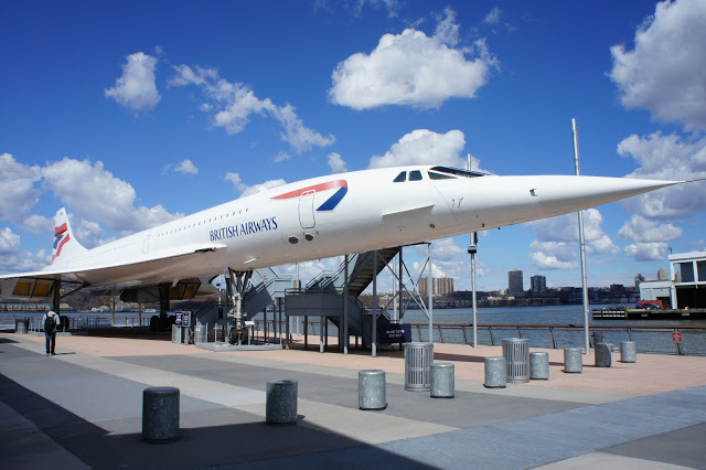
On Pier 86 itself, right next to the Intrepid, sits a Concorde. Formerly the world's fastest passenger jet, the Concorde _flew an express Atlantic service in half the time of ordinary jets, but it struggled for profitability, and the planes were retired in 2003. The plane's distinctive swept-back wings (necessary since it flies faster than the speed of sound!) and pointed nose (this actually has a mechanism to drop down for takeoff and landing to give the pilot a less obstructed view) give it an aesthetic unmatched by any other commercial jet; it's simply striking to look at. There is free entry to the pier (though to enter you still need to go through the _Intrepid museum ticket line and request a pier entry ticket), so you can actually walk right up to the Concorde without paying. Entering the plane and seeing inside requires a special ticket on top of the regular museum entry fee, and since the space shuttle was off limits, I didn't feel like it would be worth it. But as a sucker for things that fly, just being able to walk around the plane and see it up close was enough for me.
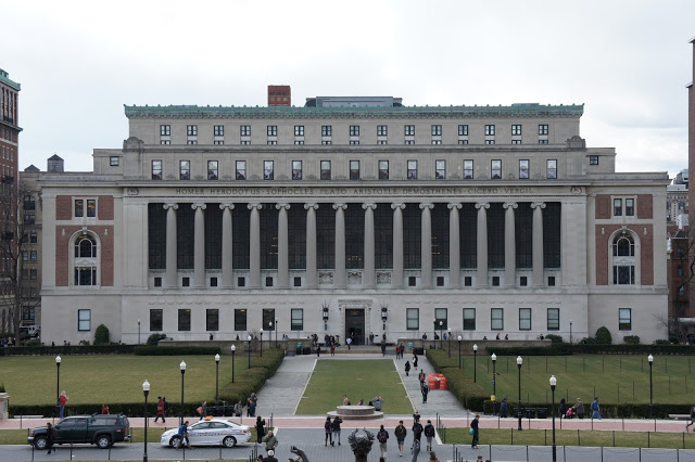
I still had a substantial amount of time to kill, so I hopped on the subway north to check out Columbia University in Morningside Heights, up on the north west edge of Manhattan Island. One of the prestigious Ivy League private universities, the Columbia campus is a welcome departure from the steel skyscrapers of Midtown. The buildings are neoclassical in style, and I found the Butler Library (above) particularly striking. I ambled through the Low Library (now the administrative centre for the university), found the computer science building, and grabbed some sushi for lunch in one of the student cafes. The campus is enormous, and all of this quickly consumed the couple of hours I had to spare before the cruise. My time thus exhausted, I headed back south to Pier 83 for the ferry ride.
The Circle Line ferries are large, with two levels, inside and outside seating, and cafe amenities for refreshments along the way. Upon departing from Pier 83, the ferry proceeds south down the Hudson River, circling Manhattan Island in a counter-clockwise direction. One of the staff members provides a narration of the passing slights along the way, sharing vast amounts of interesting tidbits about the sights of New York City.
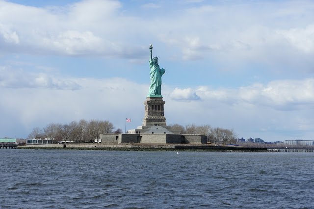
One of the undisputed highlights of the trip was the Statue of Liberty, originally gifted to the US by the people of France. The statue stands on Liberty Island just off the south coast of Manhattan, and represents Libertas, the Roman goddess of freedom. The tablet in her hand bears the date of the American Declaration of Independence, and the statue itself is renowned as a symbol of welcome to immigrants arriving in the United States. It's quite thrilling seeing her up close, particularly as a temporary visitor to these shores. Whilst clouds came and went over the course of our ferry ride, the sun won out as we passed Lady Liberty.
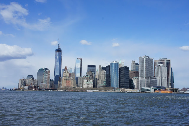
Rounding past Liberty Island and around the south edge of Manhattan, we got a fantastic view of Battery Park (the clump of trees on the shore) and the skyscrapers of the Financial District. The tallest skyscraper is the Freedom Tower at One World Trade Center, which was still under construction at the time and missing its crowning spire. The sight of these proud buildings gleaming in the sun was simply amazing.
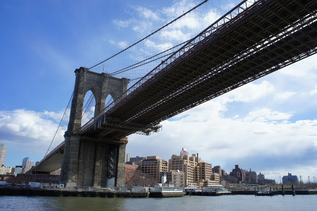
The ferry proceeded north up the East River, which separates Manhattan from the borough of Brooklyn. Brooklyn is the most populous of New York's boroughs; if it were a city upon itself, its 2.5 million people would make it the third most populous in the United States after Los Angeles and Chicago. Here we began to pass the first of many bridges connecting Manhattan to the mainland. There are a multitude of bridges and tunnels criss-crossing the rivers, carrying vehicle traffic, subways, heavy rail, pedestrians, pipes, power, and more, with each new construction often breaking records set by the previous one. We sailed underneath the iconic Brooklyn Bridge, which I had walked partway across the previous day. Our guide told us a useful mnemonic for remembering the bridges between Manhattan and Brooklyn: (B)rooklyn, (M)anhattan, and (W)illiamsburg from south to north.
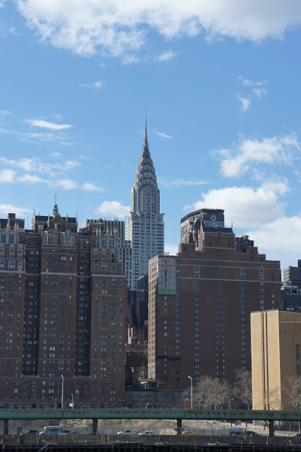
As we continued north, we found ourselves with a pristine view of the famous Chrysler Building. I don't know what it is about the city of New York, but there are so many buildings here that one can see and instantly recognise. Today Chrysler is by no means the largest skyscraper in the city, but to see it is to immediately realise what it is.
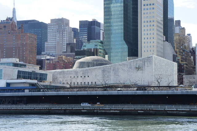
Further north up the East River is the headquarters of the United Nations. The entire complex is technically not part of New York; treaty arrangements recognise the site as under the jurisdiction of the UN, though the city still provides it with essential services. The ugly looking concrete eyesore in the photo above is actually the building that houses the United Nations General Assembly - the primary deliberative organisation of the group. I found it strange that such a titular building in the world's primary forum for international relations could be so unpleasant to look at.
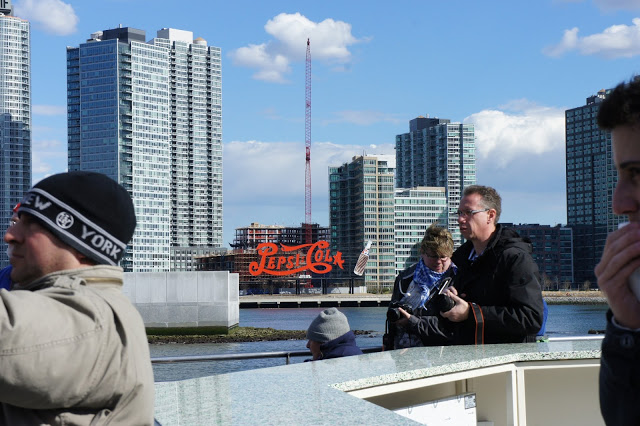
Brooklyn eventually gives way to the borough of Queens, home of New York's two major airports (LaGuardia to the north, and JFK to the south). At 2.2 million people, it's just a little smaller than Brooklyn, and would be the fourth most populous in the US as an independent city. On its western edge is the Gantry Plaza State Park, perched on the waterfront at Long Island City. A former Pepsi bottling plant, the area has been reclaimed as public land, and all that remains of the bottling operation is the preserved sign, now a centrepiece of the park and yet another iconic symbol of the city. It's visible from the Empire State Building, and has been featured in many films set in the city.
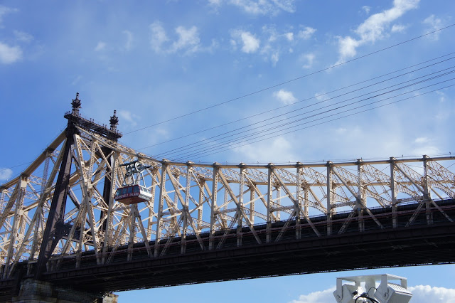
There are many small islands in the New York Bay area along the East and Harlem Rivers. One of them is Roosevelt Island, named for Franklin Roosevelt. It's long and skinny at 3 kilometres by 240 metres across at its widest point. Just 10,000 people live on the island; in years gone by it was the site of a penitentiary, a long-term care hospital, and a lighthouse. The 59th Street Bridge (recently and controversially renamed the Ed Koch Queensboro Bridge after a former Mayor of the city) passes directly over the island in connecting Manhattan and Queens, and alongside the bridge runs the Roosevelt Island Tramway - an elevated trolley line that carries passengers from Manhattan to the island. For some reason, I found the concept of a quaint elevated tramway in New York, the shining example of mass public transport in the United States, to be unreasonably amusing.
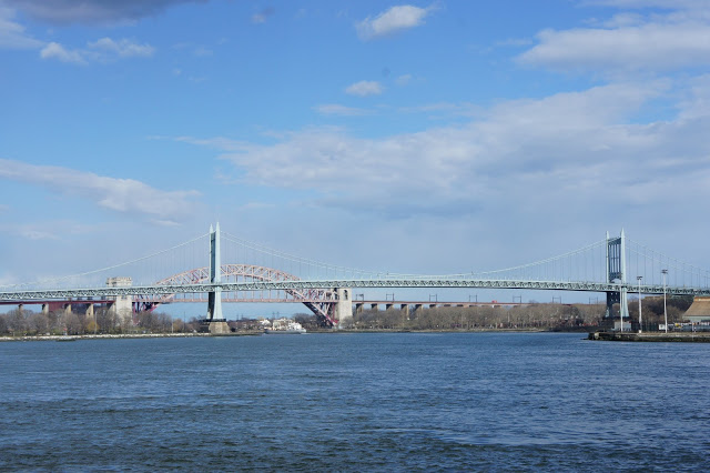
Near the junction between the Harlem and East Rivers is the Triborough Bridge (grey-green in the foreground above), which connects the three boroughs of Manhattan, Queens, and the Bronx over three island-hopping spans. In the background is the Hell Gate Bridge, named after the section of the East River that it crosses. Painted in now-faded "hell red", the bridge was the original inspiration for the Sydney Harbour Bridge, and I for one am very pleased that the arch design won out over the alternative cantilever design. If the Hell Gate Bridge looks a bit squashy in the picture above, it's because our bridge in Sydney is half again as big - the red one spans just 310 metres, whilst Sydney Harbour Bridge spans 504 metres.
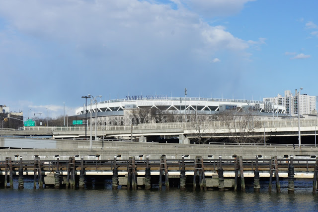
As we turned north west up the Harlem River, the borough of the Bronx came into view. Directly north of Manhattan, the Bronx is the only borough of New York that is actually located on the mainland US; the four other boroughs are all on islands. Perhaps the most famous icon we passed was Yankee Stadium, home to the eponymous New York baseball team. Opened in 2009, the stadium cost a controversial $1.5 billion, and replaced the older Yankee Stadium that became an American icon from its opening in 1923.
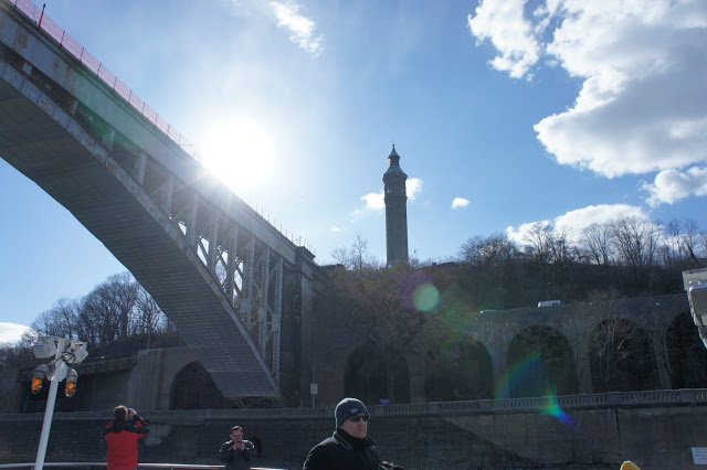
Not all of New York's bridges carry traffic. The High Bridge over the Harlem River between The Bronx and Manhattan operated as an aqueduct, carrying water from the Croton River to the northeast into Manhattan. The engineering required to construct the aqueduct system is astounding; it was built in the mid 1800's at a time when New York was ravaged by diseases caused by poor sanitation. The aqueduct was purely powered by gravity; stretching for over 50km, it sloped downwards about 20 centimetres per kilometre, slowly drawing the water to the receiving reservoir on Manhattan Island. Today, the High Bridge no longer carries water, and newer aqueducts and tunnels have superseded the Old Croton system. Currently under refurbishment, the bridge will reopen to pedestrian traffic in 2014.
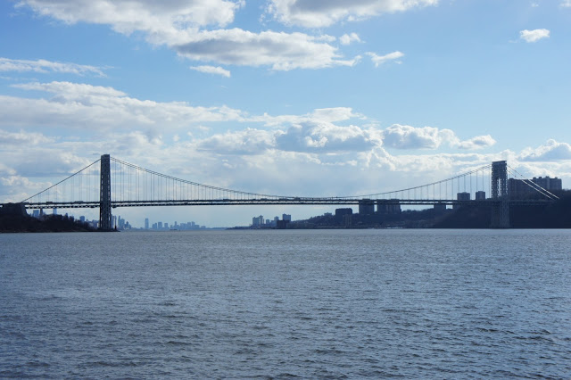
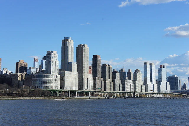
Having rounded the north end of the island (passing by the Sputyen Duyvil rail swing bridge on the way), the boat turned south on the Hudson River to complete our circle of Manhattan. Along the way we passed the George Washington Bridge. This is a behemoth of a bridge; its double decks carry 14 lanes of traffic in total, and it reportedly has the highest vehicular capacity of any bridge in the world. When it opened in 1931, the GW had the longest span of any suspension bridge in the world until the 1937 opening of the Golden Gate Bridge.
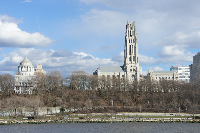
As the board passed Morningside Heights and the area of the Columbia University campus, we passed two more notable landmarks on the upper west side. On the left above is the tomb of Ulysses S. Grant, commanding general of the Union forces in the American Civil War, and 18th President of the United States. On the right is the enormous Riverside Church. Having spotted them, I resolved to visit them proper before I left the city (and I'll talk about that visit in the next post).
Many rooftops in New York are dotted with large water tanks holding tens of thousands of litres - there are over a dozen in the photo above. These water towers are necessary to supply water pressure to the upper floors of a building; pumping the water solely from the ground requires much higher pressures that can burst pipes. The water is also used for firefighting purposes; indeed, as New York grew upwards in the 19th century, buildings taller than six stories were legally required to have a water tower, partially for the water supply, but also to assuage fears regarding safety in case of flames. The tanks look like a relic from another era - many are constructed of unpainted wood as paint taints the water supply, and steel is substantially more expensive. In recent times, residents have been finding more inventive uses for the tanks - some of them have been repurposed for hidden (illegal) nightclubs and bars, accessible only by those in the know or possessed of a special invitation. I'm not kidding.
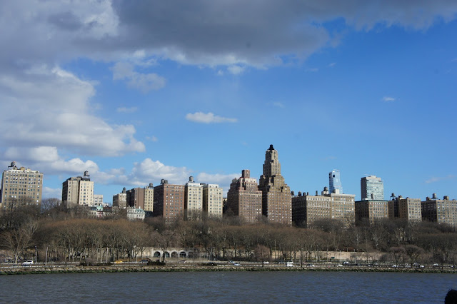
I found this curious row of tall buildings just past Morningside Heights, and right before the row of piers that marked the end of our ferry ride. I don't actually know what they are, but I found something of their composition amusing. Minutes after I took this shot, we sailed past the Intrepid and back into Pier 83, bringing the cruise to an end. It was a truly worthwhile way to see the whole of Manhattan, as well as gain a bit of the history of the city, its bridges, and its sights.
That evening, I headed to the Alphabet City (so named because it is east of 1st Avenue, so the streets are Avenue A, Avenue B, etc.) for dinner with some old friends from Sydney. I had met Courtney and Camilla many years ago when we worked as student ambassadors for the University of Sydney, and now Courtney was living in New York, while Camilla was spending a few months in the city prior to starting work. We ate at a pasta restaurant named Paprika, on St Marks Place, and both the food and the company were wonderful. It's an amazing thing to be able to reunite with old friends halfway around the world in a city as large and exciting as New York. I headed home in a very cheerful frame of mind, looking forward to more exploring the next day.